Natural Bridge Caverns

Natural Bridge Caverns
Natural Bridge Caverns, an incredible underground world of natural beauty.

TEXAS WILD FLOWERS

Saturday, October 9, 2010

Utah Hwy 12 The Mystical Side


Casto Canyon Road off of Hwy 12 leads to not only Casto Canyon but Losee Canyon as well. There are a number of trails accessible from both trail heads.


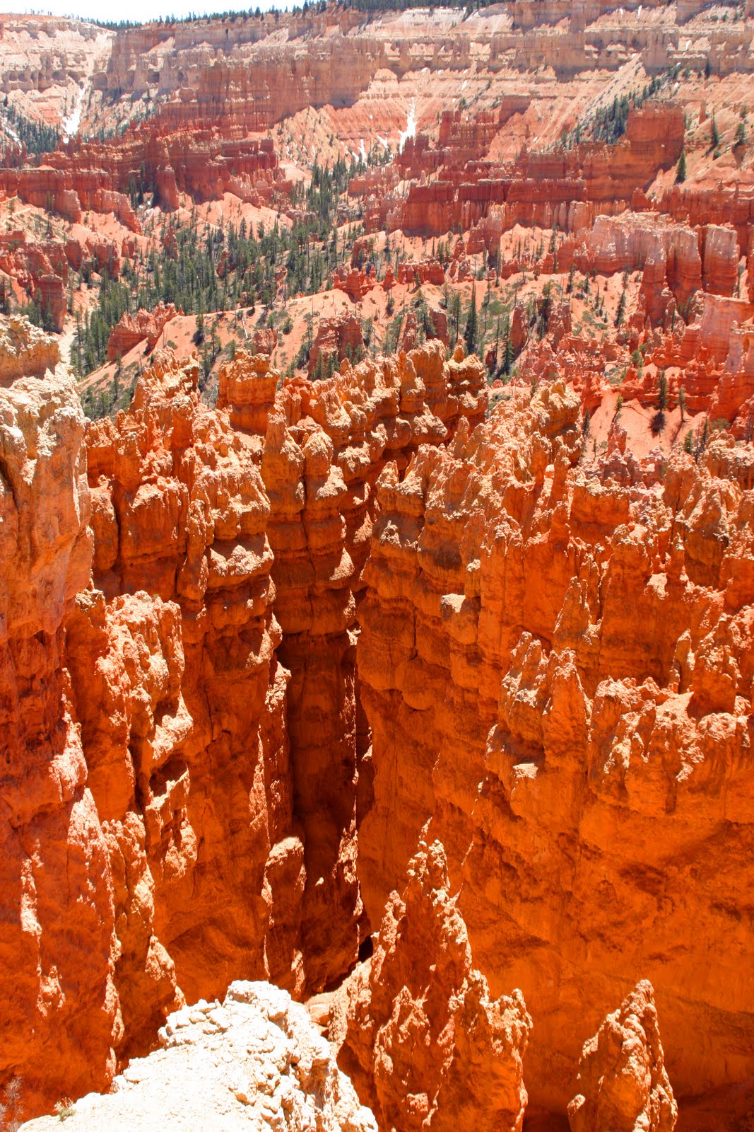
Fairy Princess Castle and village.


Bear and I are going to check out the village. Lets see what we can find.


Apparently the Fairy Princess rides a camel.


Never wake a sleeping serpent.


Did Thor were a crown or is this King Neptune's.


What do you suppose that dragon is looking for.


Now are these two from Alice In Wonder Land or Star Wars.


I think its the Fairy Princess talking to one of her loyal subjects.


This is not moder art, maybe ancient art, or at least a couple hundred years in the making.


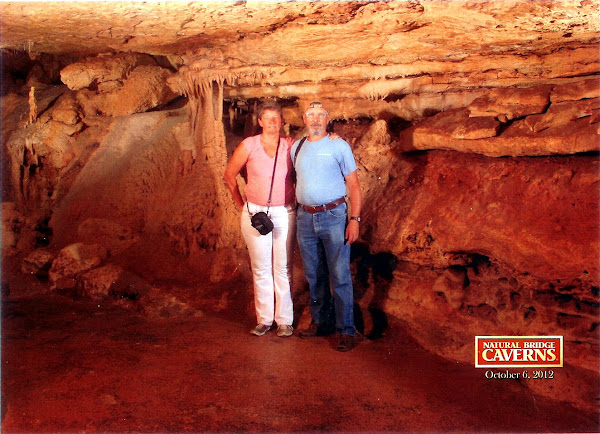
This is Mossy Cave. I didn't find any moss but the ice stays for sometime once the weather warms up.


The column of ice from flour to celling is 6 to 7 feet tall.


This beautiful waterfall is actually man made. In 1890 the settlers in Bryce Valley needed water in order to survive. They hand-dug a 10 mile canal across the Paunsaugunt Plateau from the East Fork of the Sevier River to this drainage, now known as Water Canyon.


Tuesday, October 5, 2010

Utah's Hwy 12 Red Canyon


The Guardians of Red Canyon. These hoodoos can be seen from Hwy 12 as you approach the Red Canyon Visitors Center from the west.


After stopping at the visitors center for trail maps Bear and I head up toward the hoodoos.


Approaching the hoodoos we slip in behind the Guardians.


This would be were the Guardians hang out when they are not on duty.


Bear finds an arch.


This would be a Bears eye view through the arch.


Bear really likes the views from the arches.


Check this one out.


Continuing up the Canyon past the Guardians.


We come to the end of this trail. Wow! What a view from up here. Hwy 12 is below us, we are looking south and slightly west along the west rim of the Paunsaugunt Plateau.


Eileen, Bella, and Bear rest at the end of the trail.

The pink, orange and red color in the rocks is from iron oxide in the lime stone. In other words the place is rusting away. But after 35 to 50 million years left out in the weather what would you expect.


After leaving the visitors center and heading east on Hwy 12 we pass through 2 tunnels. The tunnels were opened in the summer of 1925, making it possible to see Bryce Canyon National Park by motor car. The second tunnel is visible just around the bend.


Sunday, October 3, 2010

Bryce Canyon


Bryce Canyon rim and amphitheater from Bryce Point.


Nearly same shot, different person, camera, and lens.


An interesting study of cameras and lenses. This arch is photographed by Eileen with her camera.


A few feet away I photograph the same arch centering a tree in the opening.


Life on the Rim is harsh even for trees.


On some days this arch is easily mist. The contrast or lack of it, and you just do not see the opening.


The Wall of Window from Inspiration Point.


Hoodoos from Inspiration Point


Hoodoo - to cast a spell - a pillar of rock left by erosion. Paiutes, who lived in this region, accounted for the hoodoos as the "Legend People" whom coyote had turned to stone.


Eileen's step dad, Jim and Ronnel enjoyed the shuttle tour of Bryce Canyon with us.


In the distance to the left is Boat Mesa.


Thor's Hammer from the rim at Sunset Point.


Wall Street formation in the amphitheater from Sunset Point.


Again Wall Street.


From walls to castles and strange creaters, what ever you call them Bryce Canyon has been a work in progress for 10 million years.


Check out this guy, I think that's Remy. You remember the rat from Ratatouille. OK, mayby not.

Friday, October 1, 2010

What we did last summer

We are now in Terry, Mt. Waiting for temperature to drop so they can start the sugar beet harvest. We will be working at the Powder River Piling Station.


After leaving the Bryce Canyon area in late May we made a stop at Zion National Park. Then we spent three weeks in Las Vegas. Made our annual trip to Reno and headed to our summer job in Hill City, SD.


Eileen worked for Mountain Treats(Ice Cream and Fudge Shop) and I worked for Desperado's Restaurant. We answered an add for Mountain Treats, Dave wasn't sure he could meet the hours we requested, but said he could come close and would talk to other merchants in Hill City.


Keystone is the closest town to the Memorial, but Hill City is on the fastest route with the best highway. Iron Mountain road out of Keystone is the most scenic and the oldest route with all the pig tails. We tried both and rode the 1880's train from Hill City to Keystone.


We are not sure were we will be going after the beet harvest. If the weather cools without becoming wet the harvest will only last about two weeks. Mean while I will try to post all the picture I can starting with the Bryce area.

Sunday, June 13, 2010


On April 16th we left the ranch and the valley for the last time. We headed for the Thousand Trails preserve, Verdi Valley near Cottonwood, AZ.


Our Motor Home sat on the ranch in view of the road for six and a half months. The road was traveled many times a day by the Boarder Patrol. Many time the ranch was visited by them. Eileen was stopped and asked if she was lost after leaving the ranch in the Motor Home.

Your Federal taxes at work.


This was taken from a sign at the Palatki Ruins.


Clicking on the picture will enlarge it to full screen.


A part of the ruins.


This is just a small part of the housing that remains. That's stacking a lot of rock.


All of witch is built in to an eroded part of the cliff.


Due to trees and other foliage the ruins are not visible from the trail.


Indian Paint Brush along the trail to the ruins.


As well as other colorful flowers.


From another sign at the site, a definition Art and graffiti.


A room use presumably for such things as various ceremonies, education, and gatherings.


With a number of drawings.


Drawings of animals and people.


Symbols that meant different things to different people.


When and who the drawings were done are not necessarily known.


The cliff were these ruins are. Note the black stains left by warming and cooking fire on the cliff walls.


Moving on in to Sedona this is on the GPS tour of the area.


Chapel of the Holy Cross. Built on top of a cliff over looking the Sedona area.


Rock formations called the Nuns keep a watch of the chapel.


Courthouse Rock


Bell Rock


The Cathedral


The Cathedral stands above Oak Creek.


A place where many weddings take place. There were two the day we were there. Each with there Owen photographer.


To the right of the photographer and on the other side of the creek you can see two painters.
Although my photo is a little soft the painting I can see looks like the Cathedral.